
Make a donation
Gear up for your next adventure:
As an Amazon Associate, this site earns from qualifying purchases at no extra cost to you.
Tojais topographic map
Click on the map to display elevation.
Make a donation
Gear up for your next adventure:
As an Amazon Associate, this site earns from qualifying purchases at no extra cost to you.
About this map
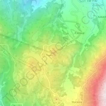
Name: Tojais topographic map, elevation, terrain.
Location: Tojais, Ribeira de Pena, Vila Real, 4880-083, Portugal (41.43607 -7.82439 41.43617 -7.82429)
Average elevation: 780 m
Minimum elevation: 497 m
Maximum elevation: 1,194 m
Make a donation
Gear up for your next adventure:
As an Amazon Associate, this site earns from qualifying purchases at no extra cost to you.
Other topographic maps
Click on a map to view its topography, its elevation and its terrain.
Parque Municipal de Ribeira de Pena
Portugal > Vila Real > Ribeira de Pena > Ribeira de Cima
Average elevation: 526 m
Make a donation
Gear up for your next adventure:
As an Amazon Associate, this site earns from qualifying purchases at no extra cost to you.