
Leibnitz topographic map
Click on the map to display elevation.
About this map
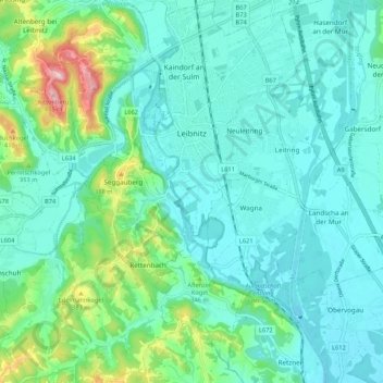
Name: Leibnitz topographic map, elevation, terrain.
Location: Leibnitz, Bezirk Leibnitz, Styria, 8430, Austria (46.73298 15.50220 46.80578 15.56986)
Average elevation: 297 m
Minimum elevation: 252 m
Maximum elevation: 479 m
Other topographic maps
Click on a map to view its topography, its elevation and its terrain.
Lamperstätten
Austria > Styria > Bezirk Leibnitz > Sankt Nikolai im Sausal > Mollitsch
Average elevation: 322 m