Geolocate

Behia topographic map

Click on the map to display elevation.

About this map

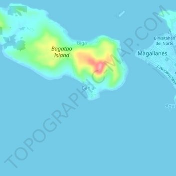
Name: Behia topographic map, elevation, terrain.

Location: Behia, Magallanes, Sorsogon, Bicol Region, 4705, Philippines (12.80062 123.79940 12.84062 123.83940)

Average elevation: 8 m

Minimum elevation: 0 m

Maximum elevation: 116 m

Gear up for your next adventure:

🎒Fully Waterproof Backpack - Total protection for photography gear and electronics
🔋Emergency Crank Radio - Weather alerts and power without needing batteries
🎒Backpack Rain Cover - External shield to keep your entire pack dry
Lightweight Backpacking Tent - Compact tent for efficient hiking trips
🧦Merino Wool Socks - Moisture-wicking comfort for long-distance hiking

As an Amazon Associate, this site earns from qualifying purchases at no extra cost to you.