Geolocate

Sagpon topographic map

Click on the map to display elevation.

About this map

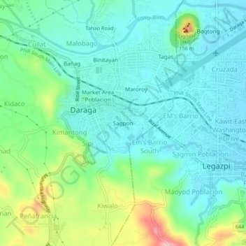
Name: Sagpon topographic map, elevation, terrain.

Location: Sagpon, Albay, Bicol Region, 4501, Philippines (13.12581 123.69870 13.16581 123.73870)

Average elevation: 51 m

Minimum elevation: 6 m

Maximum elevation: 183 m

Other topographic maps

Click on a map to view its topography, its elevation and its terrain.

Peñaranda Park

Philippines > Albay > Legazpi > Baño

Average elevation: 37 m

Malilipot

Philippines > Albay

Average elevation: 262 m

Rapu-Rapu

Philippines > Albay

Average elevation: 18 m

Gear up for your next adventure:

🥾Approach Boots - Comfortable boots for hiking and climbing approaches
🧥Packable Rain Jacket - Breathable waterproof layer for unpredictable weather
🎒Hiking Daypack - Lightweight and durable backpacks for day trips and excursions
🧥Waterproof Pants - Keep dry during rainy hiking conditions
Family Camping Tent - Spacious tent suitable for family camping trips

As an Amazon Associate, this site earns from qualifying purchases at no extra cost to you.