
Make a donation
Gear up for your next adventure:
As an Amazon Associate, this site earns from qualifying purchases at no extra cost to you.
Sants-Montjuïc topographic map
Click on the map to display elevation.
Make a donation
Gear up for your next adventure:
As an Amazon Associate, this site earns from qualifying purchases at no extra cost to you.
About this map
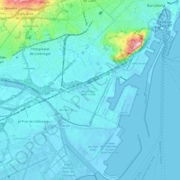
Name: Sants-Montjuïc topographic map, elevation, terrain.
Average elevation: 16 m
Minimum elevation: -3 m
Maximum elevation: 185 m
Make a donation
Gear up for your next adventure:
As an Amazon Associate, this site earns from qualifying purchases at no extra cost to you.
Other topographic maps
Click on a map to view its topography, its elevation and its terrain.
Montjuïc
Espagne > Catalogne > Barcelonais > Barcelone
Montjuïc est une montagne culminant à 185 mètres d'altitude et dominant la vieille ville, le port et le vieux port de la ville de Barcelone.
Average elevation: 39 m
Baluard de Migdia i Muralla de Mar
Espagne > Catalogne > Barcelonais > Barcelone
Average elevation: 13 m