Geolocate

Aspai topographic map

Click on the map to display elevation.

About this map

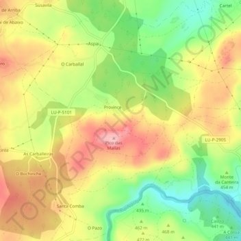
Name: Aspai topographic map, elevation, terrain.

Location: Aspai, Outeiro de Rei, Lugo, Galicia, España (43.06132 -7.68810 43.09595 -7.65088)

Average elevation: 463 m

Minimum elevation: 383 m

Maximum elevation: 538 m

Other topographic maps

Click on a map to view its topography, its elevation and its terrain.

Cabarcos

España > Galicia > Lugo > Outeiro de Rei > Vilela Pequena

Average elevation: 411 m

A Laciana

España > Galicia > Lugo > Outeiro de Rei

Average elevation: 423 m

Aspai

España > Galicia > Lugo > Outeiro de Rei

Average elevation: 474 m

Santa Isabel

España > Galicia > Lugo > Outeiro de Rei

Average elevation: 412 m

Aspai

España > Galicia > Lugo > Outeiro de Rei

Average elevation: 474 m

Gear up for your next adventure:

👟Sport Hiking Sandals - Breathable footwear for water crossings and camp rest
🔭Compact Monocular - One-handed bird watching and trail spotting
🛁Quick-Dry Microfiber Towel - Space-saving towel that dries rapidly on the move
🔦LED Flashlight - Powerful and long-lasting flashlight for camping and emergencies
🧤Insulated Winter Gloves - Heavy-duty protection for sub-zero Canadian adventures

As an Amazon Associate, this site earns from qualifying purchases at no extra cost to you.