
Make a donation
Gear up for your next adventure:
As an Amazon Associate, this site earns from qualifying purchases at no extra cost to you.
Oosteeklo topographic map
Click on the map to display elevation.
Make a donation
Gear up for your next adventure:
As an Amazon Associate, this site earns from qualifying purchases at no extra cost to you.
Oosteeklo
Oosteeklo ligt in Zandig Vlaanderen op een hoogte tot 8 meter. Ten zuiden van Oosteeklo zijn enkele bossen. Waterlopen zijn de Muurbosbeek, de Hollemeersbeek, de Moerbeek en de Bellenstroom.
Make a donation
Gear up for your next adventure:
As an Amazon Associate, this site earns from qualifying purchases at no extra cost to you.
About this map
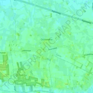
Name: Oosteeklo topographic map, elevation, terrain.
Location: Oosteeklo, Assenede, Eeklo, Oost-Vlaanderen, België (51.16776 3.66020 51.21144 3.73075)
Average elevation: 6 m
Minimum elevation: 2 m
Maximum elevation: 11 m
Make a donation
Gear up for your next adventure:
As an Amazon Associate, this site earns from qualifying purchases at no extra cost to you.
Other topographic maps
Click on a map to view its topography, its elevation and its terrain.