Geolocate

Montecillo topographic map

Click on the map to display elevation.

About this map

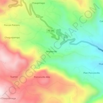
Name: Montecillo topographic map, elevation, terrain.

Location: Montecillo, Cajamarca, Perú (-7.12089 -78.59587 -7.08089 -78.55587)

Average elevation: 3,228 m

Minimum elevation: 2,904 m

Maximum elevation: 3,615 m

Other topographic maps

Click on a map to view its topography, its elevation and its terrain.

Río Mashcón

Perú > Cajamarca > Cajamarca

Average elevation: 2,905 m

Gear up for your next adventure:

🧭GPS Handheld Device - Reliable GPS navigation for outdoor adventures
🧰Emergency Multi-Tool - Compact multi-tool for outdoor survival
🪜Heavy Duty Carabiners - Multi-use clips for securing gear to your backpack
🔋Emergency Crank Radio - Weather alerts and power without needing batteries
🧦Thermal Socks - Warm socks for winter hiking or camping

As an Amazon Associate, this site earns from qualifying purchases at no extra cost to you.