
Make a donation
Gear up for your next adventure:
As an Amazon Associate, this site earns from qualifying purchases at no extra cost to you.
Sutton topographic map
Click on the map to display elevation.
Make a donation
Gear up for your next adventure:
As an Amazon Associate, this site earns from qualifying purchases at no extra cost to you.
Sutton
Sutton is a town in Merrimack County, New Hampshire, United States. The population was 1,978 at the 2020 census.[2] Sutton includes the villages of Sutton Mills (shown as "Sutton" on topographic maps), North Sutton, South Sutton and East Sutton. North Sutton is home to Wadleigh State Park on Kezar Lake.
Make a donation
Gear up for your next adventure:
As an Amazon Associate, this site earns from qualifying purchases at no extra cost to you.
About this map
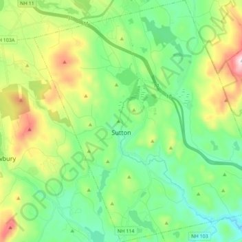
Name: Sutton topographic map, elevation, terrain.
Location: Sutton, Merrimack County, New Hampshire, United States (43.27820 -72.01426 43.40276 -71.84834)
Average elevation: 327 m
Minimum elevation: 135 m
Maximum elevation: 769 m
Make a donation
Gear up for your next adventure:
As an Amazon Associate, this site earns from qualifying purchases at no extra cost to you.