Geolocate

Eagle Bay topographic map

Click on the map to display elevation.

About this map

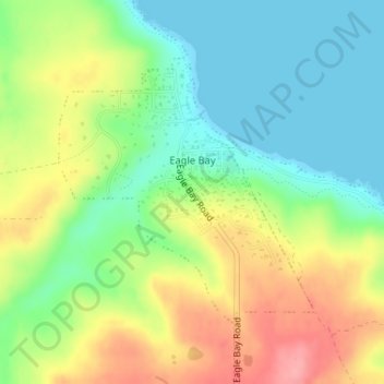
Name: Eagle Bay topographic map, elevation, terrain.

Location: Eagle Bay, City Of Busselton, Western Australia, Australia (-33.57243 115.05189 -33.55357 115.07358)

Average elevation: 41 m

Minimum elevation: 0 m

Maximum elevation: 100 m

Other topographic maps

Click on a map to view its topography, its elevation and its terrain.

Watervalley Park

Australia > Western Australia

Average elevation: 29 m

Moorehead

Australia > Western Australia

Average elevation: 197 m

Swan River

Australia > Western Australia

Average elevation: 113 m

Honeymoon Bay

Australia > Western Australia

Average elevation: 7 m

Cooke Creek

Australia > Western Australia > Onslow

Average elevation: 2 m

Kings Park

Australia > Western Australia > Perth

Average elevation: 31 m

Minah Point Yard

Australia > Western Australia

Average elevation: 220 m

Augusta

Australia > Western Australia > Augusta

Average elevation: 31 m

Ardath

Australia > Western Australia > Ardath

Average elevation: 285 m

Joondalup

Australia > Western Australia

Average elevation: 33 m

Gear up for your next adventure:

📷Outdoor Action Camera - Capture high-elevation views and rugged adventures
🪑Insulated Seat Pad - Protect your seat from cold rocks and wet logs
🥾Hiking Boots - Sturdy boots providing ankle support and traction on rugged trails
🚲Heavy Duty Bike Lock - Secure your bike at the trailhead or during stops
🧳Compression Sacks - Maximize space in your backpack by shrinking gear

As an Amazon Associate, this site earns from qualifying purchases at no extra cost to you.