Geolocate

Shap topographic map

Click on the map to display elevation.

About this map

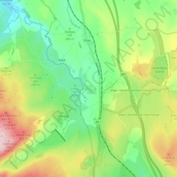
Name: Shap topographic map, elevation, terrain.

Location: Shap, Eden District, Cumbria, England, United Kingdom (54.48382 -2.70097 54.54355 -2.65485)

Average elevation: 300 m

Minimum elevation: 189 m

Maximum elevation: 484 m

Gear up for your next adventure:

🚑Survival Whistle - Signal for help across long distances in mountains
🥾Lightweight Hiking Shoes - Comfortable shoes for day hikes
🥾Trekking Poles - Adjustable trekking poles to reduce knee stress and improve stability
🔦LED Headlamp - Hands-free lighting for early morning starts or late finishes
👟Trail Running Shoes - Agile footwear for fast-paced topographic exploration

As an Amazon Associate, this site earns from qualifying purchases at no extra cost to you.