
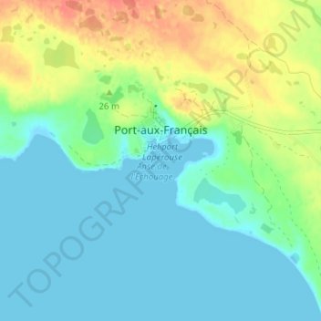
Port-aux-Français topographic map
Interactive map
Click on the map to display elevation.
About this map
Name: Port-aux-Français topographic map, elevation, terrain.
Average elevation: 14 m
Minimum elevation: -2 m
Maximum elevation: 45 m
Other topographic maps
Click on a map to view its topography, its elevation and its terrain.
La mare aux éléphants
France > French Southern and Antarctic Lands > Martin-de-Viviès
La mare aux éléphants, Martin-de-Viviès, New Amsterdam Island, Saint Paul and New Amsterdam Islands, French Southern and Antarctic Lands, France
Average elevation: 40 m
Kerguelen Archipelago
France > French Southern and Antarctic Lands
Kerguelen Archipelago, French Southern and Antarctic Lands, France
Average elevation: 38 m
Cimetière
France > French Southern and Antarctic Lands > Cimetière
Cimetière, French Southern and Antarctic Lands, France
Average elevation: 7 m