
Neukirchen topographic map
Click on the map to display elevation.
About this map
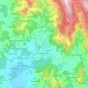
Name: Neukirchen topographic map, elevation, terrain.
Average elevation: 492 m
Minimum elevation: 327 m
Maximum elevation: 868 m
Other topographic maps
Click on a map to view its topography, its elevation and its terrain.
Grafentraubach
Deutschland > Bayern > Landkreis Straubing-Bogen
Das Pfarrdorf Grafentraubach liegt im Donau-Isar-Hügelland auf Höhen um 372 m ü. NHN am linken Rand des Tals der Kleinen Laber. Durch den Ort mündet der Grafentraubach in den Mittellauf des Flusses. Etwas über zwei Kilometer östlich liegt am anderen Rand der Flusstalaue der Gemeindesitz Laberweinting,…
Average elevation: 390 m
Niederlindhart
Deutschland > Bayern > Landkreis Straubing-Bogen > Mallersdorf-Pfaffenberg > Westen
Average elevation: 407 m
Bogenberg
Deutschland > Bayern > Landkreis Straubing-Bogen > Bogen > Bogenberg
Average elevation: 326 m
Irlbach an der Donau
Deutschland > Bayern > Landkreis Straubing-Bogen > Irlbach
Average elevation: 321 m
Untermühlbach
Deutschland > Bayern > Landkreis Straubing-Bogen > Obermühlbach
Average elevation: 477 m
St. Leonhardsquelle
Deutschland > Bayern > Landkreis Straubing-Bogen > Mitterberg
Average elevation: 808 m
Hinterdegenberg
Deutschland > Bayern > Landkreis Straubing-Bogen > Allersdorf
Average elevation: 578 m
Westen
Deutschland > Bayern > Landkreis Straubing-Bogen > Mallersdorf-Pfaffenberg
Average elevation: 410 m
Sallach
Deutschland > Bayern > Landkreis Straubing-Bogen > Geiselhöring > Sallach
Average elevation: 372 m
Talmühle
Deutschland > Bayern > Landkreis Straubing-Bogen > Scheibelsgrub > Talmühle
Average elevation: 408 m