Geolocate

Robson topographic map

Click on the map to display elevation.

About this map

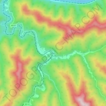
Name: Robson topographic map, elevation, terrain.

Location: Robson, Fayette County, West Virginia, 25173, United States (38.08177 -81.26372 38.12177 -81.22372)

Average elevation: 391 m

Minimum elevation: 186 m

Maximum elevation: 638 m

Other topographic maps

Click on a map to view its topography, its elevation and its terrain.

Gear up for your next adventure:

🐕Hiking Dog Pack - Let your canine companion carry their own water and food
🧶550 Survival Paracord - Versatile utility cord for emergency repairs and rigging
💧Collapsible Water Bottle - Space-saving water bottle for outdoor activities
💡Compact LED Flashlight - Powerful and portable flashlight for outdoor use
🧴First Aid Kit - Essential first aid supplies for outdoor emergencies

As an Amazon Associate, this site earns from qualifying purchases at no extra cost to you.