Geolocate

Villahormes topographic map

Click on the map to display elevation.

About this map

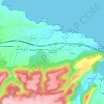
Name: Villahormes topographic map, elevation, terrain.

Location: Villahormes, Llanes, Asturias, 33954, España (43.42120 -4.92199 43.46120 -4.88199)

Average elevation: 66 m

Minimum elevation: -1 m

Maximum elevation: 225 m

Gear up for your next adventure:

🧦Hiking Liner Socks - Thin base layer to prevent friction and blisters
🐕Hiking Dog Pack - Let your canine companion carry their own water and food
🎒Backpack Rain Cover - External shield to keep your entire pack dry
💧Hydration Pack - Hands-free hydration system for long hikes
💧Hydration Bladder - Hands-free hydration solution for long treks

As an Amazon Associate, this site earns from qualifying purchases at no extra cost to you.