Geolocate

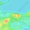
Fitchburg topographic map

Click on the map to display elevation.

About this map
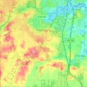
Name: Fitchburg topographic map, elevation, terrain.

Location: Fitchburg, Dane County, Wisconsin, United States (42.94294 -89.48696 43.03940 -89.36483)

Average elevation: 299 m

Minimum elevation: 258 m

Maximum elevation: 365 m

Other topographic maps

Click on a map to view its topography, its elevation and its terrain.

Waunakee Marsh

United States > Wisconsin > Dane County > Waunakee

Average elevation: 292 m

Buss's Corners

United States > Wisconsin > Dane County

Average elevation: 289 m

Burke

United States > Wisconsin > Dane County > Madison

Average elevation: 292 m

Table Bluff

United States > Wisconsin > Dane County

Average elevation: 306 m

Frederick's Hill

United States > Wisconsin > Dane County

Average elevation: 279 m

Stoughton

United States > Wisconsin > Dane County > Stoughton

Average elevation: 270 m

Bowens Addition

United States > Wisconsin > Dane County > Madison

Average elevation: 266 m

Marxville

United States > Wisconsin > Dane County > Town of Berry

Average elevation: 300 m

East Bristol

United States > Wisconsin > Dane County

Average elevation: 285 m

Gear up for your next adventure:

🥾Trail Running Shoes - Lightweight and durable shoes for trail running
🧦Outdoor Socks - Durable socks designed for hiking and outdoor sports
🧤Insulated Winter Gloves - Heavy-duty protection for sub-zero Canadian adventures
🧥Insulated Jacket - Keep warm in cold outdoor conditions
🧭Orienteering Kit - Tools for map reading and navigation in the wild

As an Amazon Associate, this site earns from qualifying purchases at no extra cost to you.