Geolocate

Burke topographic map

Click on the map to display elevation.

About this map

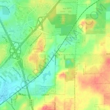
Name: Burke topographic map, elevation, terrain.

Location: Burke, Madison, Dane County, Wisconsin, 53718, United States (43.11583 -89.29623 43.15583 -89.25623)

Average elevation: 292 m

Minimum elevation: 260 m

Maximum elevation: 329 m

Other topographic maps

Click on a map to view its topography, its elevation and its terrain.

Capitol Square

United States > Wisconsin > Dane County > Madison

Average elevation: 262 m

Monona Bay

United States > Wisconsin > Dane County > Madison

Average elevation: 266 m

Gear up for your next adventure:

Family Camping Tent - Spacious tent suitable for family camping trips
🔋Solar Power Bank - Keep your GPS and devices charged during long outdoor trips
🧴Bear Spray Holster - Quick-access carry for essential Canadian wilderness safety
🚲Heavy Duty Bike Lock - Secure your bike at the trailhead or during stops
🧳Compression Sacks - Maximize space in your backpack by shrinking gear

As an Amazon Associate, this site earns from qualifying purchases at no extra cost to you.