Geolocate

Aruba topographic map

Click on the map to display elevation.

About this map
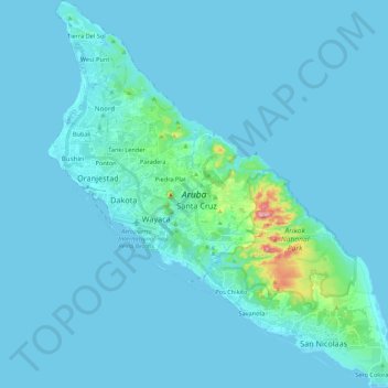
Name: Aruba topographic map, elevation, terrain.

Location: Aruba, Netherlands (12.41183 -70.06384 12.62337 -69.86546)

Average elevation: 11 m

Minimum elevation: -2 m

Maximum elevation: 189 m

Other topographic maps

Click on a map to view its topography, its elevation and its terrain.
Amsterdam

Netherlands > North Holland > Amsterdam

Average elevation: -1 m

Oosterwijzend

Netherlands > North Holland > Hoogkarspel

Average elevation: -2 m

Oud-Zevenaar

Netherlands > Gelderland > Zevenaar

Average elevation: 12 m

Wittewierum

Netherlands > Groningen > Ten Post

Average elevation: -1 m

Meuse

Netherlands > Limburg > Baarlo

Average elevation: 22 m

Hout

Netherlands > North Brabant > Geldrop

Average elevation: 22 m

Zuidbarge

Netherlands > Drenthe > Emmen

Average elevation: 20 m

Groningen

Netherlands > Groningen > Groningen

Average elevation: 2 m

Gear up for your next adventure:

🔦UV Flashlight - Detect minerals or specific insects in the dark
🧤Insulated Winter Gloves - Heavy-duty protection for sub-zero Canadian adventures
🧢Outdoor Visor - Breathable visor for sunny hikes
💧Reusable Water Bottle - Durable water bottles for hydration on trails
💧Filtered Water Bottle - Safe drinking water on the go

As an Amazon Associate, this site earns from qualifying purchases at no extra cost to you.