Geolocate

Serveto topographic map

Click on the map to display elevation.

About this map

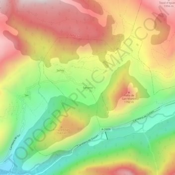
Name: Serveto topographic map, elevation, terrain.

Location: Serveto, Plan, Sobrarbe, Huesca, Aragón, 22366, España (42.56117 0.27538 42.60117 0.31538)

Average elevation: 1,443 m

Minimum elevation: 876 m

Maximum elevation: 2,025 m

Other topographic maps

Click on a map to view its topography, its elevation and its terrain.

Boltaña

España > Aragón > Sobrarbe

Average elevation: 859 m

Tella-Sin

España > Aragón > Sobrarbe

Average elevation: 1,448 m

Embalse de Mediano

España > Aragón > Sobrarbe

Average elevation: 649 m

La Fueva

España > Aragón > Sobrarbe

Average elevation: 923 m

Cañón de Añisclo

España > Aragón > Sobrarbe

Average elevation: 1,487 m

Gear up for your next adventure:

🥾Hiking Shoes - Durable and comfortable shoes for trail hiking
🚲MTB Frame Bag - Carry tools and maps directly on your bicycle frame
🎒Backpack Rain Cover - External shield to keep your entire pack dry
🔭Outdoor Binoculars - Lightweight binoculars for birdwatching and hiking
❄️Traction Ice Cleats - Slip-on spikes for icy trails and winter hiking

As an Amazon Associate, this site earns from qualifying purchases at no extra cost to you.