
Punta Vergajo topographic map
Click on the map to display elevation.
About this map
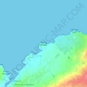
Name: Punta Vergajo topographic map, elevation, terrain.
Location: Punta Vergajo, Santander, Cantabria, 39012, España (43.49027 -3.82447 43.49037 -3.82437)
Average elevation: 10 m
Minimum elevation: -1 m
Maximum elevation: 71 m
Other topographic maps
Click on a map to view its topography, its elevation and its terrain.
Isla de la Virgen del Mar
España > Cantabria > Santander > San Román de la Llanilla > El Rostrío
Average elevation: 8 m