Geolocate

Lattenbuch topographic map

Click on the map to display elevation.

About this map

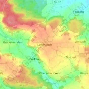
Name: Lattenbuch topographic map, elevation, terrain.

Location: Lattenbuch, Herrieden, Landkreis Ansbach, Bayern, Deutschland (49.17833 10.43487 49.21833 10.47487)

Average elevation: 465 m

Minimum elevation: 425 m

Maximum elevation: 504 m

Gear up for your next adventure:

🎒Hiking Backpack - Lightweight and ergonomic backpacks for day hikes or multi-day treks
🗺️Topographic Maps - Detailed maps to explore trails, mountains, and wilderness areas
🔭Outdoor Binoculars - Lightweight binoculars for birdwatching and hiking
🔦LED Flashlight - Powerful and long-lasting flashlight for camping and emergencies
🎒Hiking Daypack - Lightweight and durable backpacks for day trips and excursions

As an Amazon Associate, this site earns from qualifying purchases at no extra cost to you.