Geolocate

Chapel Hill topographic map

Click on the map to display elevation.

About this map

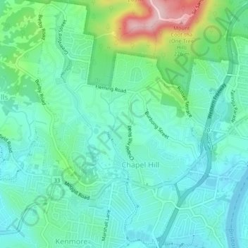
Name: Chapel Hill topographic map, elevation, terrain.

Location: Chapel Hill, Brisbane City, Queensland, Australia (-27.51696 152.93588 -27.48190 152.96207)

Average elevation: 56 m

Minimum elevation: 3 m

Maximum elevation: 226 m

Other topographic maps

Click on a map to view its topography, its elevation and its terrain.

Willmington Park

Australia > Queensland > Brisbane City

Average elevation: 37 m

Mount Gravatt

Australia > Queensland > Brisbane City

Average elevation: 70 m

Ithaca

Australia > Queensland > Brisbane City > Ithaca

Average elevation: 31 m

Gear up for your next adventure:

🧢Hiking Hat - Sun-protective and breathable hats for long treks
🔦UV Flashlight - Detect minerals or specific insects in the dark
🪑Insulated Seat Pad - Protect your seat from cold rocks and wet logs
🧭GPS Tracker - Track your location in remote areas safely
🎒Backpack Rain Cover - External shield to keep your entire pack dry

As an Amazon Associate, this site earns from qualifying purchases at no extra cost to you.