
Fuejo topographic map
Click on the map to display elevation.
About this map
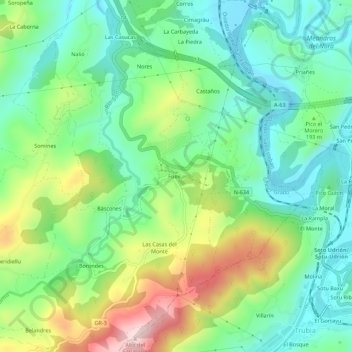
Name: Fuejo topographic map, elevation, terrain.
Location: Fuejo, Báscones, Grado, Asturias, 33825, España (43.34403 -6.00938 43.38403 -5.96938)
Average elevation: 178 m
Minimum elevation: 58 m
Maximum elevation: 421 m
Other topographic maps
Click on a map to view its topography, its elevation and its terrain.
Sorribas
Las edificaciones que conforman el lugar de Sorribas se asientan en el tercio superior de la ladera noroccidental de la cuenca del arroyo Tarallongo y en el collado divisorio de esta vaguada con la del río Vega. Se orientan al sudeste, a una altitud que oscila entre los 450 y los 530 m s. n. m.
Average elevation: 368 m
Rodiles
El lugar de Rodiles se asienta en un rellano situado a media ladera, en la vertiente suroriental de la cuenca baja del río Cubia, a una altitud que ronda los 370 m s. n. m. Dista 8 km aproximadamente de la capital, Grado, y se accede a través de la carretera local de 1.º orden AS-311.
Average elevation: 357 m