Geolocate

Sabaudia topographic map

Click on the map to display elevation.

About this map

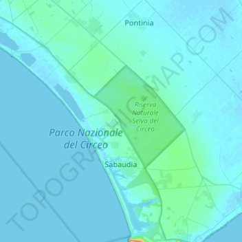
Name: Sabaudia topographic map, elevation, terrain.

Location: Sabaudia, Latina, Lazio, 04016, Italy (41.24309 12.91520 41.42561 13.11684)

Average elevation: 10 m

Minimum elevation: -3 m

Maximum elevation: 199 m

Other topographic maps

Click on a map to view its topography, its elevation and its terrain.

Borgo Bainsizza

Italy > Lazio > Latina > Latina

Average elevation: 27 m

Le Cupe

Italy > Lazio > Latina > Itri

Average elevation: 318 m

Campoleone Scalo

Italy > Lazio > Latina > Aprilia

Average elevation: 124 m

Gear up for your next adventure:

💧Hydration Bladder - Hands-free hydration solution for long treks
💧Filtered Water Bottle - Safe drinking water on the go
🌡️Emergency Mylar Blankets - Compact thermal protection for unexpected nights outdoors
Camping Coffee Maker - Brew fresh coffee anywhere on the topographic map
💧Collapsible Water Bottle - Space-saving water bottle for outdoor activities

As an Amazon Associate, this site earns from qualifying purchases at no extra cost to you.