
Thank you for supporting this site ❤️
Make a donation
Make a donation
Gear up for your next adventure:
As an Amazon Associate, this site earns from qualifying purchases at no extra cost to you.
Paveto topographic map
Click on the map to display elevation.
Thank you for supporting this site ❤️
Make a donation
Make a donation
Gear up for your next adventure:
As an Amazon Associate, this site earns from qualifying purchases at no extra cost to you.
About this map
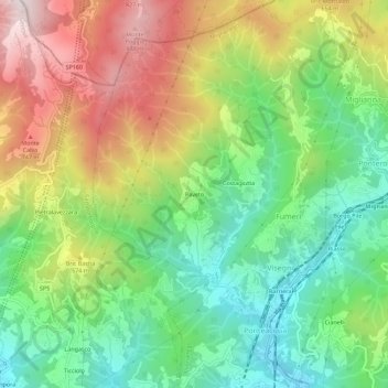
Name: Paveto topographic map, elevation, terrain.
Location: Paveto, Fumeri, Mignanego, Genova, Liguria, 16018, Italia (44.51938 8.88294 44.55938 8.92294)
Average elevation: 448 m
Minimum elevation: 139 m
Maximum elevation: 897 m
Thank you for supporting this site ❤️
Make a donation
Make a donation
Gear up for your next adventure:
As an Amazon Associate, this site earns from qualifying purchases at no extra cost to you.