Geolocate

Port Barton topographic map

Click on the map to display elevation.

About this map

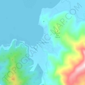
Name: Port Barton topographic map, elevation, terrain.

Location: Port Barton, Roxas, Palawan, Mimaropa, 5309, Philippines (10.39140 119.15796 10.43140 119.19796)

Average elevation: 77 m

Minimum elevation: -1 m

Maximum elevation: 434 m

Other topographic maps

Click on a map to view its topography, its elevation and its terrain.

Coconut Beach

Philippines > Palawan > Roxas

Average elevation: 23 m

Long Beach

Philippines > Palawan > Roxas > San Isidro

Average elevation: 4 m

Purao Island

Philippines > Palawan > Roxas

Average elevation: 0 m

Stanlake Island

Philippines > Palawan > Roxas

Average elevation: 0 m

Boayan

Philippines > Palawan > Roxas

Average elevation: 12 m

Gear up for your next adventure:

🥾Trail Hiking Shoes - Durable shoes designed for rugged trails
🥾Mountain Hiking Boots - High-traction boots for rocky terrain
🧴Sunscreen SPF - Broad-spectrum sunscreen for outdoor activities
🥾Trail Hiking Boots - Supportive boots for rough trails
🛶Canoe Life Vest - Safety vest for water sports

As an Amazon Associate, this site earns from qualifying purchases at no extra cost to you.