Geolocate

Hartville topographic map

Click on the map to display elevation.

About this map

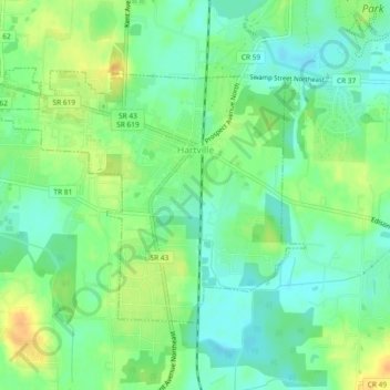
Name: Hartville topographic map, elevation, terrain.

Location: Hartville, Stark County, Ohio, 44632, United States (40.94816 -81.36446 40.97102 -81.31817)

Average elevation: 355 m

Minimum elevation: 341 m

Maximum elevation: 374 m

Other topographic maps

Click on a map to view its topography, its elevation and its terrain.

Mount Pleasant

United States > Ohio > Stark County

Average elevation: 352 m

Deer Creek

United States > Ohio > Stark County > Lexington

Average elevation: 319 m

Sippo Heights

United States > Ohio > Stark County > Massillon

Average elevation: 318 m

Cairo

United States > Ohio > Stark County

Average elevation: 349 m

Lake Cable

United States > Ohio > Stark County

Average elevation: 340 m

North Industry

United States > Ohio > Stark County

Average elevation: 333 m

New Franklin

United States > Ohio > Stark County

Average elevation: 365 m

Gear up for your next adventure:

🧥Softshell Hiking Jacket - The perfect balance of wind protection and breathability
🥾Hiking Boots - Sturdy boots providing ankle support and traction on rugged trails
🚑Survival Whistle - Signal for help across long distances in mountains
🥾Mountain Hiking Boots - High-traction boots for rocky terrain
📷Outdoor Action Camera - Capture high-elevation views and rugged adventures

As an Amazon Associate, this site earns from qualifying purchases at no extra cost to you.