Geolocate

Beaver Point topographic map

Click on the map to display elevation.

About this map

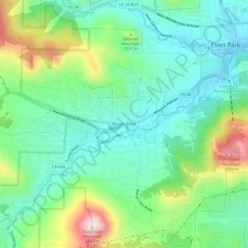
Name: Beaver Point topographic map, elevation, terrain.

Location: Beaver Point, Estes Park, Larimer County, Colorado, 80517, United States (40.34440 -105.56468 40.38440 -105.52468)

Average elevation: 2,432 m

Minimum elevation: 2,294 m

Maximum elevation: 2,759 m

Other topographic maps

Click on a map to view its topography, its elevation and its terrain.

Gear up for your next adventure:

🥫Freeze-Dried Meals - Lightweight, high-calorie nutrition for multi-day treks
🥾Hiking Shorts - Breathable shorts suitable for summer hikes
🐕Hiking Dog Pack - Let your canine companion carry their own water and food
💡Portable Camping Lamp - Rechargeable lamp for campsite lighting
💧Filtered Water Bottle - Safe drinking water on the go

As an Amazon Associate, this site earns from qualifying purchases at no extra cost to you.