Geolocate

Murlo topographic map

Click on the map to display elevation.

About this map

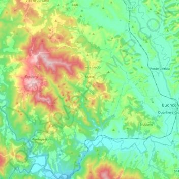
Name: Murlo topographic map, elevation, terrain.

Location: Murlo, Siena, Tuscany, 53016, Italy (43.07957 11.27582 43.22166 11.43080)

Average elevation: 227 m

Minimum elevation: 109 m

Maximum elevation: 502 m

Other topographic maps

Click on a map to view its topography, its elevation and its terrain.

Santa Chiara

Italy > Tuscany > Siena > San Gimignano

Average elevation: 255 m

Valle Saccaia

Italy > Tuscany > Siena > Cetona

Average elevation: 706 m

Belverde

Italy > Tuscany > Siena

Average elevation: 316 m

Gear up for your next adventure:

Camping Groundsheet - Protect your tent from moisture and dirt
💡LED Headlamp - Hands-free illumination for night hiking and camping
🧴Sunscreen SPF - Broad-spectrum sunscreen for outdoor activities
🔨Vehicle Emergency Tool - Safety tool for remote road trips to trailheads
🥾Trail Running Boots - Durable shoes designed for trail running

As an Amazon Associate, this site earns from qualifying purchases at no extra cost to you.