
Make a donation
Gear up for your next adventure:
As an Amazon Associate, this site earns from qualifying purchases at no extra cost to you.
Puy-de-Dôme topographic map
Click on the map to display elevation.
Make a donation
Gear up for your next adventure:
As an Amazon Associate, this site earns from qualifying purchases at no extra cost to you.
About this map
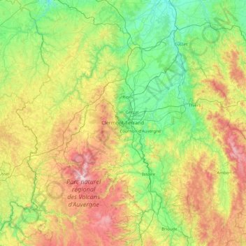
Name: Puy-de-Dôme topographic map, elevation, terrain.
Location: Puy-de-Dôme, Auvergne-Rhône-Alpes, Metropolitan France, France (45.28705 2.38802 46.25629 3.98563)
Average elevation: 659 m
Minimum elevation: 209 m
Maximum elevation: 1,850 m
Make a donation
Gear up for your next adventure:
As an Amazon Associate, this site earns from qualifying purchases at no extra cost to you.
Other topographic maps
Click on a map to view its topography, its elevation and its terrain.
Les Résidences
France > Auvergne-Rhône-Alpes > Puy-de-Dôme > Murat-le-Quaire
Average elevation: 1,072 m
Siaugues-Saint-Romain
France > Auvergne-Rhône-Alpes > Haute-Loire > Siaugues-Sainte-Marie
Average elevation: 951 m
Make a donation
Gear up for your next adventure:
As an Amazon Associate, this site earns from qualifying purchases at no extra cost to you.
Tré-le-Champ - le Haut
France > Auvergne-Rhône-Alpes > Upper Savoy > Chamonix-Mont-Blanc
Average elevation: 1,737 m
Tré-le-Champ - le Bas
France > Auvergne-Rhône-Alpes > Upper Savoy > Chamonix-Mont-Blanc > Tré-le-Champ - le Bas
Average elevation: 1,724 m
Make a donation
Gear up for your next adventure:
As an Amazon Associate, this site earns from qualifying purchases at no extra cost to you.
Le Planet
France > Auvergne-Rhône-Alpes > Chamonix-Mont-Blanc > Argentière > Le Planet
Average elevation: 1,672 m
La Maranche
France > Auvergne-Rhône-Alpes > Loire > Saint-Bonnet-le-Courreau > La Maranche
Average elevation: 894 m
Make a donation
Gear up for your next adventure:
As an Amazon Associate, this site earns from qualifying purchases at no extra cost to you.