
Make a donation
Gear up for your next adventure:
As an Amazon Associate, this site earns from qualifying purchases at no extra cost to you.
Ladenburg topographic map
Click on the map to display elevation.
Make a donation
Gear up for your next adventure:
As an Amazon Associate, this site earns from qualifying purchases at no extra cost to you.
Ladenburg
Die Gemarkung liegt auf dem Neckarschwemmkegel in 96 bis 106 Metern Höhe in der Oberrheinischen Tiefebene und erstreckt sich über 1900 Hektar. Die Flächennutzung ist wie folgt; 27,4 Prozent Siedlungs- und Verkehrsfläche, 69,8 Prozent Vegetationsflächen, davon 69,0 Prozent landwirtschaftlich genutzt, 2,8 Prozent sind Fließgewässer.
Make a donation
Gear up for your next adventure:
As an Amazon Associate, this site earns from qualifying purchases at no extra cost to you.
About this map
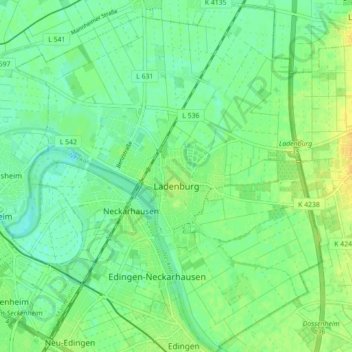
Name: Ladenburg topographic map, elevation, terrain.
Average elevation: 103 m
Minimum elevation: 93 m
Maximum elevation: 117 m
Make a donation
Gear up for your next adventure:
As an Amazon Associate, this site earns from qualifying purchases at no extra cost to you.
Other topographic maps
Click on a map to view its topography, its elevation and its terrain.
Neckar-Wimmersbach
Deutschland > Baden-Württemberg > Rhein-Neckar-Kreis > Eberbach
Average elevation: 256 m
Eiterbach
Deutschland > Baden-Württemberg > Rhein-Neckar-Kreis
Nördlich von Eiterbach liegt am Rande eines ausgedehnten Bergwaldgebietes um die Stiefelhöhe an deren östlichem Abhang in einem kleinen Seitental die romanische Kirchruine und Wallfahrtsstätte St. Maria in Lichtenklingen. Ein Parkplatz am Ende der nördlichen Sackstraße ins Tal, bereits in Hessen,…
Average elevation: 423 m
Hardtwaldsiedlung
Deutschland > Baden-Württemberg > Rhein-Neckar-Kreis > Oftersheim
Average elevation: 104 m
Make a donation
Gear up for your next adventure:
As an Amazon Associate, this site earns from qualifying purchases at no extra cost to you.