Geolocate

Kootwijk topographic map

Click on the map to display elevation.

About this map

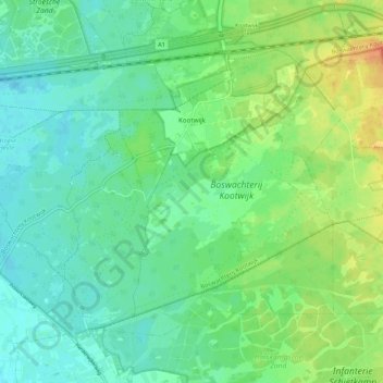
Name: Kootwijk topographic map, elevation, terrain.

Location: Kootwijk, Barneveld, Gelderland, Netherlands (52.14760 5.70486 52.19699 5.81193)

Average elevation: 31 m

Minimum elevation: 18 m

Maximum elevation: 58 m

Other topographic maps

Click on a map to view its topography, its elevation and its terrain.

Elden

Netherlands > Gelderland > Arnhem

Average elevation: 11 m

Slingeplas

Netherlands > Gelderland > Bredevoort

Average elevation: 29 m

Veldhoek

Netherlands > Gelderland

Average elevation: 18 m

Zwin

Netherlands > Gelderland > Bern > Bern

Average elevation: 3 m

Ubbergen

Netherlands > Gelderland > Ubbergen > Ubbergen

Average elevation: 32 m

Arnhem

Netherlands > Gelderland > Arnhem

Average elevation: 24 m

Gear up for your next adventure:

🥾Light Trekking Boots - Supportive boots for multi-day treks
🛏️Sleeping Bag - Warm and compact sleeping bags for outdoor camping
🛶Waterproof Dry Bags - Keep electronics and clothes dry during river crossings
🥾Waterproof Trail Shoes - Shoes designed to handle wet terrain
🛶Kayak Accessories - Essential gear for safe and fun kayaking adventures

As an Amazon Associate, this site earns from qualifying purchases at no extra cost to you.