Geolocate

Uruapan topographic map

Click on the map to display elevation.

About this map

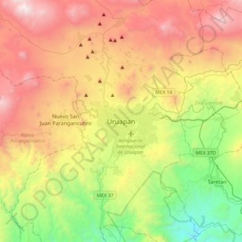
Name: Uruapan topographic map, elevation, terrain.

Location: Uruapan, Michoacán, 60050, Mexico (19.25473 -102.21226 19.57473 -101.89226)

Average elevation: 1,800 m

Minimum elevation: 651 m

Maximum elevation: 3,272 m

Gear up for your next adventure:

🥾Light Hiking Boots - Lightweight and comfortable boots for day hikes
🔋Lithium AA Batteries - Long-lasting power that performs in extreme cold
👟Trail Running Shoes - Agile footwear for fast-paced topographic exploration
💡Portable Camping Lamp - Rechargeable lamp for campsite lighting
🥾Light Trekking Boots - Supportive boots for multi-day treks

As an Amazon Associate, this site earns from qualifying purchases at no extra cost to you.