
Thank you for supporting this site ❤️
Make a donation
Make a donation
Gear up for your next adventure:
As an Amazon Associate, this site earns from qualifying purchases at no extra cost to you.
Gimte topographic map
Click on the map to display elevation.
Thank you for supporting this site ❤️
Make a donation
Make a donation
Gear up for your next adventure:
As an Amazon Associate, this site earns from qualifying purchases at no extra cost to you.
About this map
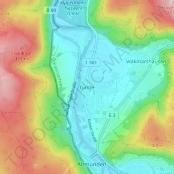
Name: Gimte topographic map, elevation, terrain.
Average elevation: 214 m
Minimum elevation: 114 m
Maximum elevation: 391 m
Thank you for supporting this site ❤️
Make a donation
Make a donation
Gear up for your next adventure:
As an Amazon Associate, this site earns from qualifying purchases at no extra cost to you.
Other topographic maps
Click on a map to view its topography, its elevation and its terrain.
Forstbotanischer Garten
Deutschland > Niedersachsen > Landkreis Göttingen > Hann. Münden
Average elevation: 182 m
34346
Deutschland > Niedersachsen > Landkreis Göttingen > Hann. Münden > Volkmarshausen
Average elevation: 286 m