
Make a donation
Gear up for your next adventure:
As an Amazon Associate, this site earns from qualifying purchases at no extra cost to you.
Varallo topographic map
Click on the map to display elevation.
Make a donation
Gear up for your next adventure:
As an Amazon Associate, this site earns from qualifying purchases at no extra cost to you.
Varallo
Der Ort liegt im Valsesia auf einer Höhe von 450 m über dem Meeresspiegel. Das Gemeindegebiet umfasst eine Fläche von 88 km². und hat 6926 Einwohner (Stand 31. Dezember 2022).
Make a donation
Gear up for your next adventure:
As an Amazon Associate, this site earns from qualifying purchases at no extra cost to you.
About this map
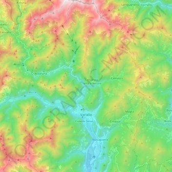
Name: Varallo topographic map, elevation, terrain.
Location: Varallo, Vercelli, Piemont, 13019, Italien (45.76579 8.17838 45.90982 8.33591)
Average elevation: 994 m
Minimum elevation: 383 m
Maximum elevation: 2,107 m
Make a donation
Gear up for your next adventure:
As an Amazon Associate, this site earns from qualifying purchases at no extra cost to you.
Other topographic maps
Click on a map to view its topography, its elevation and its terrain.