Geolocate

Belfair topographic map

Click on the map to display elevation.

About this map

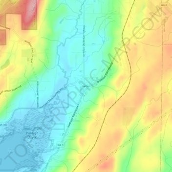
Name: Belfair topographic map, elevation, terrain.

Location: Belfair, Mason County, Washington, United States (47.43226 -122.84654 47.47226 -122.80654)

Average elevation: 63 m

Minimum elevation: -2 m

Maximum elevation: 159 m

Other topographic maps

Click on a map to view its topography, its elevation and its terrain.

Shelton

United States > Washington > Mason County

Average elevation: 54 m

Allyn

United States > Washington > Mason County > Allyn

Average elevation: 47 m

Belfair

United States > Washington > Mason County

Average elevation: 65 m

Oakland Bay

United States > Washington > Mason County > Shelton

Average elevation: 36 m

Price Lake

United States > Washington > Mason County

Average elevation: 326 m

Allyn

United States > Washington > Mason County > Allyn

Average elevation: 47 m

Lake Cushman

United States > Washington > Mason County

Average elevation: 410 m

Belfair

United States > Washington > Mason County

Average elevation: 65 m

Grapeview

United States > Washington > Mason County

Average elevation: 17 m

Gear up for your next adventure:

🏕️Camping Hammock - Integrated protection for sleeping between trees
🧢Sun Protection Cap - Breathable cap to protect from sun exposure
🧴Outdoor Sunscreen - High SPF protection for high-altitude UV exposure
🔨Vehicle Emergency Tool - Safety tool for remote road trips to trailheads
💡Compact LED Flashlight - Powerful and portable flashlight for outdoor use

As an Amazon Associate, this site earns from qualifying purchases at no extra cost to you.