
Make a donation
Gear up for your next adventure:
As an Amazon Associate, this site earns from qualifying purchases at no extra cost to you.
Bruce Township topographic map
Click on the map to display elevation.
Make a donation
Gear up for your next adventure:
As an Amazon Associate, this site earns from qualifying purchases at no extra cost to you.
Bruce Township
The highest point in Macomb County, Twombly Mountain, lies within the Ford Motor Company Proving Grounds, rising to an altitude of 1,150 feet (350 meters).
Make a donation
Gear up for your next adventure:
As an Amazon Associate, this site earns from qualifying purchases at no extra cost to you.
About this map
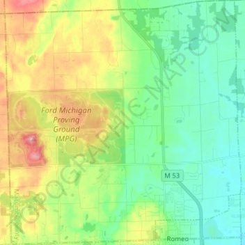
Name: Bruce Township topographic map, elevation, terrain.
Average elevation: 265 m
Minimum elevation: 224 m
Maximum elevation: 344 m
Make a donation
Gear up for your next adventure:
As an Amazon Associate, this site earns from qualifying purchases at no extra cost to you.
Other topographic maps
Click on a map to view its topography, its elevation and its terrain.
Chesterfield Shores
United States > Michigan > Macomb County > Chesterfield Township
Average elevation: 178 m
Forest Lake
United States > Michigan > Macomb County > Shelby Charter Township
Average elevation: 202 m
Sterling Heights
United States > Michigan > Macomb County > Sterling Heights > Sterling Heights
Average elevation: 205 m
Make a donation
Gear up for your next adventure:
As an Amazon Associate, this site earns from qualifying purchases at no extra cost to you.