
Thank you for supporting this site ❤️
Make a donation
Make a donation
Gear up for your next adventure:
As an Amazon Associate, this site earns from qualifying purchases at no extra cost to you.
Dayuma topographic map
Click on the map to display elevation.
Thank you for supporting this site ❤️
Make a donation
Make a donation
Gear up for your next adventure:
As an Amazon Associate, this site earns from qualifying purchases at no extra cost to you.
About this map
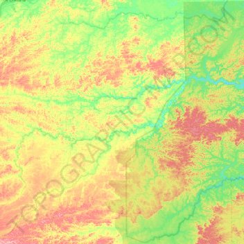
Name: Dayuma topographic map, elevation, terrain.
Location: Dayuma, Francisco de Orellana, Orellana, Ecuador (-0.91184 -77.00176 -0.49746 -76.54806)
Average elevation: 284 m
Minimum elevation: 214 m
Maximum elevation: 374 m
Thank you for supporting this site ❤️
Make a donation
Make a donation
Gear up for your next adventure:
As an Amazon Associate, this site earns from qualifying purchases at no extra cost to you.
Other topographic maps
Click on a map to view its topography, its elevation and its terrain.
Puerto Francisco de Orellana
Ecuador > Orellana > Francisco de Orellana > Puerto Francisco de Orellana
Average elevation: 255 m