
Make a donation
Gear up for your next adventure:
As an Amazon Associate, this site earns from qualifying purchases at no extra cost to you.
Salta topographic map
Click on the map to display elevation.
Make a donation
Gear up for your next adventure:
As an Amazon Associate, this site earns from qualifying purchases at no extra cost to you.
Salta
Although Salta Province is located near the Tropic of Capricorn, it has a wide range of climates due to variation in altitude and the influence of orography. The orientation of the Andes influences the distribution of precipitation within the province.
Make a donation
Gear up for your next adventure:
As an Amazon Associate, this site earns from qualifying purchases at no extra cost to you.
About this map
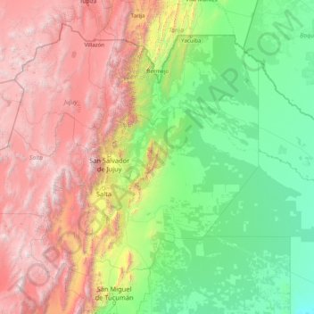
Name: Salta topographic map, elevation, terrain.
Location: Salta, Argentina (-26.41670 -68.56789 -21.99877 -62.33923)
Average elevation: 1,630 m
Minimum elevation: 104 m
Maximum elevation: 6,196 m
Make a donation
Gear up for your next adventure:
As an Amazon Associate, this site earns from qualifying purchases at no extra cost to you.
Other topographic maps
Click on a map to view its topography, its elevation and its terrain.