Geolocate

Belerda topographic map

Click on the map to display elevation.

About this map

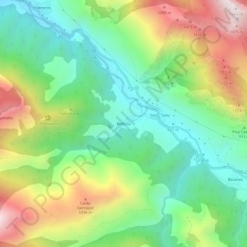
Name: Belerda topographic map, elevation, terrain.

Location: Belerda, Caso, Asturias, 33996, España (43.14031 -5.33549 43.18031 -5.29549)

Average elevation: 926 m

Minimum elevation: 560 m

Maximum elevation: 1,540 m

Gear up for your next adventure:

🥾Light Trekking Boots - Supportive boots for multi-day treks
🧢Sun Hat - Wide-brim hat for sun protection
🥾Waterproof Hiking Shoes - Durable shoes for wet and rugged trails
🛌Insulated Sleeping Pad - Critical thermal barrier between you and the cold ground
🥾Light Hiking Boots - Lightweight and comfortable boots for day hikes

As an Amazon Associate, this site earns from qualifying purchases at no extra cost to you.