
Twizel topographic map
Click on the map to display elevation.
About this map
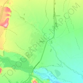
Name: Twizel topographic map, elevation, terrain.
Location: Twizel, Mackenzie District, Canterbury, 7901, New Zealand (-44.29748 170.05941 -44.21748 170.13941)
Average elevation: 472 m
Minimum elevation: 411 m
Maximum elevation: 592 m
Other topographic maps
Click on a map to view its topography, its elevation and its terrain.
Tasman Glacier
New Zealand > Canterbury > Mackenzie District
At 23.5 kilometres (14.6 mi) in length, Tasman Glacier is still New Zealand's longest glacier, despite shrinking considerably from the 1990s onwards. It is as much as 4 kilometres (2.5 mi) wide and 600 metres (2,000 ft) thick, and lies entirely within the borders of Aoraki / Mount Cook National Park. The…
Average elevation: 1,884 m
Aoraki / Mount Cook National Park
New Zealand > Canterbury > Mackenzie District
Temperatures in Mount Cook Village range between extremes of −13 °C (9 °F) to 32 °C (90 °F), and typically fall just over 1 °C (34 °F) for every 200 metres (660 ft) of additional altitude.
Average elevation: 1,386 m
Lake Tekapo
New Zealand > Canterbury > Mackenzie District
Lake Tekapo (Māori: Takapō) is the second-largest of three roughly parallel lakes running north–south along the northern edge of the Mackenzie Basin in the South Island of New Zealand (the others are Lake Pukaki and Lake Ōhau). It covers an area of 83 square kilometres (32 sq mi) and is at an altitude of…
Average elevation: 1,025 m
Aoraki / Mount Cook National Park
New Zealand > Canterbury > Mackenzie District
Temperatures in Mount Cook Village range between extremes of −13 °C (9 °F) to 32 °C (90 °F), and typically fall just over 1 °C (34 °F) for every 200 metres (660 ft) of additional altitude.
Average elevation: 1,386 m
Tasman Glacier
New Zealand > Canterbury > Mackenzie District
At 23.5 kilometres (14.6 mi) in length, Tasman Glacier is still New Zealand's longest glacier, despite shrinking considerably from the 1990s onwards. It is as much as 4 kilometres (2.5 mi) wide and 600 metres (2,000 ft) thick, and lies entirely within the borders of Aoraki / Mount Cook National Park. The…
Average elevation: 1,884 m