Geolocate

San Carlos topographic map

Click on the map to display elevation.

About this map

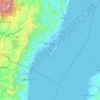
Name: San Carlos topographic map, elevation, terrain.

Location: San Carlos, Negros Occidental, Western Visayas, 6127, Philippines (10.31607 123.13245 10.60250 123.55778)

Average elevation: 190 m

Minimum elevation: -2 m

Maximum elevation: 1,851 m

Other topographic maps

Click on a map to view its topography, its elevation and its terrain.

Tinagong Dagat

Philippines > Negros Occidental > Talisay

Average elevation: 1,365 m

Lumbia

Philippines > Negros Occidental > Cauayan

Average elevation: 209 m

Tagukon

Philippines > Negros Occidental > Kabankalan

Average elevation: 129 m

Kabankalan

Philippines > Negros Occidental

Average elevation: 148 m

Minoyan

Philippines > Negros Occidental > Murcia

Average elevation: 302 m

Concepcion

Philippines > Negros Occidental > Talisay

Average elevation: 154 m

Banquerohan

Philippines > Negros Occidental > Cadiz

Average elevation: 7 m

Anahaw

Philippines > Negros Occidental > Hinigaran

Average elevation: 13 m

Central

Philippines > Negros Occidental > Sagay > Central

Average elevation: 31 m

Sibato

Philippines > Negros Occidental > Silay > Sibato

Average elevation: 260 m

Canlubang

Philippines > Negros Occidental

Average elevation: 6 m

Patag Diotay

Philippines > Negros Occidental > Silay

Average elevation: 349 m

Gear up for your next adventure:

🧊Portable Cooler - Keep food and drinks cold during outdoor adventures
🔭Outdoor Binoculars - Lightweight binoculars for birdwatching and hiking
🚑Survival Whistle - Signal for help across long distances in mountains
🧰Survival Kit - Essential gear for emergencies in the wilderness
Camping Tent - Weather-resistant tents suitable for 2 to 6 people

As an Amazon Associate, this site earns from qualifying purchases at no extra cost to you.