Geolocate

Quintes topographic map

Click on the map to display elevation.

About this map

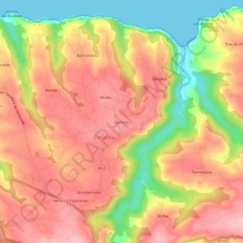
Name: Quintes topographic map, elevation, terrain.

Location: Quintes, Cimadevilla, Villaviciosa, Asturias, 33294, España (43.51241 -5.56346 43.55241 -5.52346)

Average elevation: 107 m

Minimum elevation: -1 m

Maximum elevation: 178 m

Gear up for your next adventure:

🧰Survival Kit - Essential gear for emergencies in the wilderness
🧴Outdoor Sunscreen - High SPF protection for high-altitude UV exposure
🦯Trekking Poles - Reduced impact on joints for steep topographic climbs
Tent Footprint - Protect tent floor and increase durability
🧰Emergency Multi-Tool - Compact multi-tool for outdoor survival

As an Amazon Associate, this site earns from qualifying purchases at no extra cost to you.