
Thank you for supporting this site ❤️
Make a donation
Make a donation
Gear up for your next adventure:
As an Amazon Associate, this site earns from qualifying purchases at no extra cost to you.
Hoge topographic map
Click on the map to display elevation.
Thank you for supporting this site ❤️
Make a donation
Make a donation
Gear up for your next adventure:
As an Amazon Associate, this site earns from qualifying purchases at no extra cost to you.
About this map
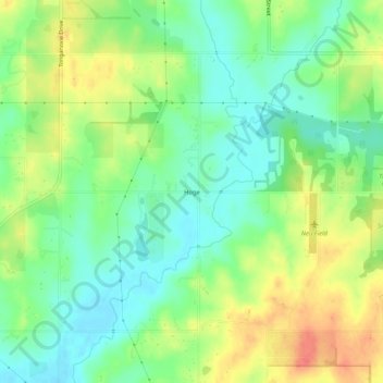
Name: Hoge topographic map, elevation, terrain.
Location: Hoge, Leavenworth County, Kansas, United States (39.15222 -95.01497 39.19222 -94.97497)
Average elevation: 276 m
Minimum elevation: 254 m
Maximum elevation: 306 m
Thank you for supporting this site ❤️
Make a donation
Make a donation
Gear up for your next adventure:
As an Amazon Associate, this site earns from qualifying purchases at no extra cost to you.
Other topographic maps
Click on a map to view its topography, its elevation and its terrain.
Fort Leavenworth
United States > Kansas > Leavenworth County > Leavenworth > Leavenworth
Average elevation: 252 m