
La Matanza topographic map
Interactive map
Click on the map to display elevation.
About this map
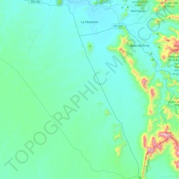
Name: La Matanza topographic map, elevation, terrain.
Location: La Matanza, Morropón, Piura, Peru (-5.58536 -80.25990 -5.15917 -79.93716)
Average elevation: 227 m
Minimum elevation: 88 m
Maximum elevation: 1,178 m
Der Distrikt La Matanza liegt im Südwesten der Provinz Morropón. Der Río Piura verläuft entlang der nördlichen Distriktgrenze nach Westen. Im äußersten Osten befindet sich der westlichste Höhenrücken der Ausläufer der peruanischen Westkordillere. Westlich davon erstreckt sich die Küstenwüste von Nordwest-Peru, die einen Großteil des Distriktgebietes umfasst. Die Längsausdehnung des Distrikts in NNW-SSO-Richtung beträgt 50 km, die maximale Breite liegt bei 30 km.
Other topographic maps
Click on a map to view its topography, its elevation and its terrain.
Distrito de Ayabaca
Peru > Piura > Distrito de Ayabaca
Distrito de Ayabaca, Ayabaca, Piura, Peru
Average elevation: 1,946 m