
Thank you for supporting this site ❤️
Make a donation
Make a donation
Gear up for your next adventure:
As an Amazon Associate, this site earns from qualifying purchases at no extra cost to you.
Sitamarhi topographic map
Click on the map to display elevation.
Thank you for supporting this site ❤️
Make a donation
Make a donation
Gear up for your next adventure:
As an Amazon Associate, this site earns from qualifying purchases at no extra cost to you.
Sitamarhi
Sitamarhi, located at 26°36′N 85°29′E / 26.6°N 85.48°E / 26.6; 85.48, has an average elevation of 56 metres (184 ft).
Thank you for supporting this site ❤️
Make a donation
Make a donation
Gear up for your next adventure:
As an Amazon Associate, this site earns from qualifying purchases at no extra cost to you.
About this map
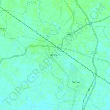
Name: Sitamarhi topographic map, elevation, terrain.
Location: Sitamarhi, Dumra, Sitamarhi District, Bihar, 843300, India (26.54765 85.46567 26.62765 85.54567)
Average elevation: 64 m
Minimum elevation: 61 m
Maximum elevation: 68 m
Thank you for supporting this site ❤️
Make a donation
Make a donation
Gear up for your next adventure:
As an Amazon Associate, this site earns from qualifying purchases at no extra cost to you.