
Make a donation
Gear up for your next adventure:
As an Amazon Associate, this site earns from qualifying purchases at no extra cost to you.
Beaver Harbour topographic map
Click on the map to display elevation.
Make a donation
Gear up for your next adventure:
As an Amazon Associate, this site earns from qualifying purchases at no extra cost to you.
About this map
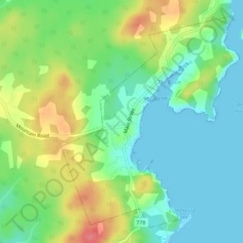
Name: Beaver Harbour topographic map, elevation, terrain.
Location: Beaver Harbour, Charlotte County, New Brunswick, Canada (45.06184 -66.75321 45.08545 -66.72505)
Average elevation: 25 m
Minimum elevation: -1 m
Maximum elevation: 70 m
Charlotte County trails, hiking, mountain biking, running and outdoor activities
Make a donation
Gear up for your next adventure:
As an Amazon Associate, this site earns from qualifying purchases at no extra cost to you.
Other topographic maps
Click on a map to view its topography, its elevation and its terrain.
Saint Andrews
Canada > New Brunswick > Charlotte County > Town of Saint Andrews
Average elevation: 7 m
Simpson Corner
Canada > New Brunswick > Charlotte County > Municipal District of St. Stephen
Average elevation: 27 m
Make a donation
Gear up for your next adventure:
As an Amazon Associate, this site earns from qualifying purchases at no extra cost to you.
Heathland
Canada > New Brunswick > Charlotte County > Municipal District of St. Stephen
Average elevation: 64 m