
Make a donation
Gear up for your next adventure:
As an Amazon Associate, this site earns from qualifying purchases at no extra cost to you.
Thollon Station topographic map
Click on the map to display elevation.
Make a donation
Gear up for your next adventure:
As an Amazon Associate, this site earns from qualifying purchases at no extra cost to you.
About this map
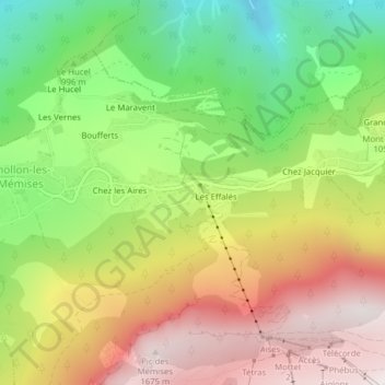
Name: Thollon Station topographic map, elevation, terrain.
Average elevation: 1,079 m
Minimum elevation: 529 m
Maximum elevation: 1,665 m
Make a donation
Gear up for your next adventure:
As an Amazon Associate, this site earns from qualifying purchases at no extra cost to you.
Other topographic maps
Click on a map to view its topography, its elevation and its terrain.
ME 15-1
France > Auvergne-Rhône-Alpes > Haute-Savoie > Thollon-les-Mémises > Les Effalés
Average elevation: 1,394 m
Pic des Mémises
France > Auvergne-Rhône-Alpes > Haute-Savoie > Thollon-les-Mémises
La montagne des Mémises est une montagne de Haute-Savoie, dans le massif du Chablais, à proximité de la frontière franco-suisse, qui culmine à 1 686 mètres d'altitude. Elle domine Évian-les-Bains, Thollon-les-Mémises et offre une vue panoramique sur le Léman, du massif du Jura aux Alpes…
Average elevation: 1,306 m
Le Grand Mottay
France > Auvergne-Rhône-Alpes > Haute-Savoie > Thollon-les-Mémises
Average elevation: 1,508 m
Make a donation
Gear up for your next adventure:
As an Amazon Associate, this site earns from qualifying purchases at no extra cost to you.