
Zottegem topographic map
Interactive map
Click on the map to display elevation.
About this map
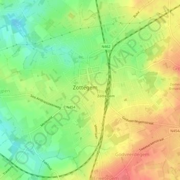
Name: Zottegem topographic map, elevation, terrain.
Location: Zottegem, Alost, Flandre orientale, Flandre, 9620, Belgique (50.86203 3.80652 50.87611 3.83739)
Average elevation: 59 m
Minimum elevation: 28 m
Maximum elevation: 89 m
Other topographic maps
Click on a map to view its topography, its elevation and its terrain.
Erpe-Mere
Belgique > Flandre orientale > Alost > Mere
Erpe-Mere, Mere, Erpe-Mere, Alost, Flandre orientale, Flandre, 9420, Belgique
Average elevation: 38 m
Velsique-Ruddershove
Belgique > Flandre orientale > Alost
Velsique-Ruddershove, Zottegem, Alost, Flandre orientale, Flandre, Belgique
Average elevation: 50 m