Geolocate

Umaria topographic map

Click on the map to display elevation.

Umaria

Umaria is located at 23°25′N 78°38′E / 23.42°N 78.63°E / 23.42; 78.63 and has an average elevation of 538 metres (1,765 feet).

Wikipedia (CC-BY-SA 3.0)

About this map

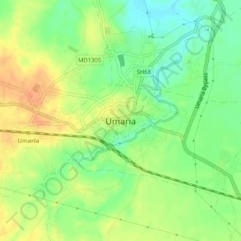
Name: Umaria topographic map, elevation, terrain.

Location: Umaria, Bandhogarh Umaria Tahsil, Umaria District, Madhya Pradesh, 484661, India (23.51144 80.80982 23.53797 80.84501)

Average elevation: 455 m

Minimum elevation: 435 m

Maximum elevation: 474 m

Gear up for your next adventure:

🛁Quick-Dry Microfiber Towel - Space-saving towel that dries rapidly on the move
🧥Thermal Layer - Insulating layer for cold outdoor conditions
🥾Approach Boots - Comfortable boots for hiking and climbing approaches
🥾Mountaineering Boots - Supportive boots for climbing and high-altitude hiking
🔥Emergency Fire Starter - Reliable ignition source for all weather conditions

As an Amazon Associate, this site earns from qualifying purchases at no extra cost to you.